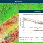
Automatic cloud-based geoinformation service for subsidence, landislide and ground motion monitoring and analysis over time.
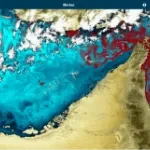
Automatic cloud-based geo-information service for the continuous monitoring of coastal seawater quality and marine resources.
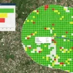
Automatic cloud-based geoinformation service platform for territorial monitoring
Automatic cloud-based geoinformation service for subsidence, landislides and groud displacement monitoring and analysis over time
Geoportal for e-Collaboration and dialogue between organizations and citizens in the planning process.
Geospatial Indexes for Territorial Planning and Strategic Environmental Assessment. Monitoring of soil loss.
Urban monitoring and automatic satellite-based detection of illegal constructions.
Geo-information products, derived from satellite data, designed to provide cognitive frameworks which meet the specific needs of each field of application.
Cognitive Framework for Urban Planning and monitoring of Strategic Environmental Assessment (SEA).