

Urban monitoring and automatic satellite-based detection of illegal constructions.
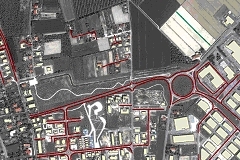
Local Public Administrations need to monitor the territory continually, in order to detect illegal constructions and use of resources, e.g. to avoid tax evasions. Preciso® urban is a smart geoinformation solution that helps PA to identify elements of change to the territory, which are potentially illegal.
Preciso® urban provides satellite-based geoinformaton to assist PA in their periodic monitoring of urban expansion and uncontroled territorial changes, in particular:
- Public and private construction (area, dimensions of new buildings, demolitions and modifications);
- Infrastructural changes
Applications
- Timely identification of anthropic territorial changes
- Control regarding planning permission
- Smart Government
- Urban area requalification planning
Who can benefit
- Public Administration (Tax offices and Urban Planning Department);
- Tax collection organizations
- Building and infrastructure companies
Benefits
- Fairness in taxation
- Increase in incoming taxes
- Prevention of illegality and environmental deterioratin
- Updated knowledge on local conditions
Technical characteristics
Preciso® urban is a ready to use, geoinformative product made up of cartographic layers and specific indicators which show the changing trend of urban areas:
- Building with information regarding perimeter, area, volume, height, condition (new, demolished or modified)
- Transport network with information regarding perimeter, area, type (roads, railways, trams), condition (new, demolished or modified)
- Construction activity Indicators (total number, total area and volume of buildings contructed, demolished or modified)
- Indicators of road expansio (total number, total area and volume of roads, railways, contructed, demolished or modified)
- Combined indicators regarding building activity and infrstucture network expansion (total area of land used for buildings and roads)
- Preciso® Italia orthoimages
Download
- The use case of Comunità Montana del Catria e Nerone (Italian Municipality) (PDF italian)
- An example of Preciso® urban in shape file format (32 Mb)
- An example dataset of Preciso® urban (PDF with layers)