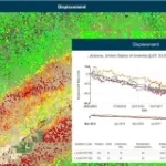
Automatic cloud-based geoinformation service for subsidence, landislide and ground motion monitoring and analysis over time.
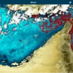
Automatic cloud-based geo-information service for the continuous monitoring of coastal seawater quality and marine resources.
Automatic cloud-based geoinformation service for subsidence, landislides and groud displacement monitoring and analysis over time
Automatic cloud-based geoinformation service platform for territorial monitoring
Geoportal for e-Collaboration and dialogue between organizations and citizens in the planning process.
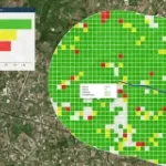
Geospatial Indexes for Territorial Planning and Strategic Environmental Assessment. Monitoring of soil loss.
Urban monitoring and automatic satellite-based detection of illegal constructions.
Cognitive Framework for Urban Planning and monitoring of Strategic Environmental Assessment (SEA).
Geo-information products, derived from satellite data, designed to provide cognitive frameworks which meet the specific needs of each field of application.