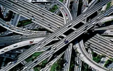
Earth Observation techniques: using Geospatial data as a support for infrastructure design, planning, construction and maintenance.
The phases of planning and design of on-shore or off-shore infrastructures, - from railways to pipelines, from highways to dams -, must include the analysys of the environment in which this infrastructure will serve. It is fundamental to evaluate the morphology of the area, the impact of the construction activities on the environmental dynamics, the possible future coexistence between works and neighboring areas.
Planetek Italia is an expert partner in the supply, in addition to satellite images, of added value services and data, obtained by merging different sources through automatic and photo-interpretation processing techniques, useful for supporting engineering companies in their activities.
In the field of the on-shore design, we provide services like:
In the field of the off-shore design, based on our sound experience in monitoring marine and coastal ecosystems, we provide services of:
Rheticus® is a satellite-based information service designed for the continuous monitoring of ground surface, infrastructures, work sites, urban dynamics or marine coastal areas. Providing actionable information in form of maps, reports, alerts and geoanalytics, Rheticus® is ready to assist managers, professionals and decision-makers in several industries with the highest precision and care.
Our main industry-focused services designed for infrastructure engineering are: Rheticus® Displacement, Rheticus® Network Alert, Rheticus® Safeway, Rheticus® Safeland, Rheticus® Building Check.
Rheticus® Displacement is targeted to: Infrastructures and works managers and builders; Public Administration; Planners & professionals in land and environmental management and protection.
Available by subscription, it provides detailed information on:
Learn more about Rheticus® services on www.rheticus.eu