
The world’s most widely-used remote sensing software package for creating information from geospatial data.

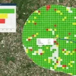
GeoMedia® is a powerful GIS management package which provides simultaneous access to geospatial data in almost any form, uniting them in a single map view for efficient processing, analysis, presen

A Complete Suite of Photogrammetric Production Tools

The largest Earth observation satellite constellation able to collect a picture of the Earth every day.

Automatic cloud-based geoinformation service for subsidence, landislide and ground motion monitoring and analysis over time.

Automatic cloud-based geo-information service for the continuous monitoring of coastal seawater quality and marine resources.

Continuous monitoring of water and sewer pipeline stability

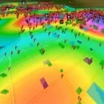
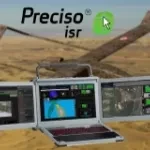
Preciso® ISR, an integrated AI-powered exploitation suite designed to enhance operational effectiveness across defence, homeland security, and civil protection missions.

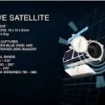
SkySat is a commercial Earth observation microsatellite constellation of Planet company licensed to collect high resolution panchromatic and multispectral images of the Earth.

SecureWatch gives you instant access to the best of DigitalGlobe | Maxar technologies satellite imagery and geospatial data.

Landslide identification and monitoring for infrastructure planning and management

Geospatial Indexes for Territorial Planning and Strategic Environmental Assessment. Monitoring of soil loss.