

Cognitive Framework for Urban Planning and monitoring of Strategic Environmental Assessment (SEA).
Nowadays, Urban Planning requires updated and exhaustive knowledge of territorial conditions, as well as operational tools to monitor the impact of this planning in time on the territory.
Preciso® land is the ideal solution for Urban Planning in that it offers a single cognitive base to initiate the planning process. It supplies timely information on the conditions of the territory, which can be updated quickly to describe the changes which have occurred. It includes geospatial indicators which can be used in the SEA (Strategic Environmental Assessment) of the plan to evaluate possible alternative and monitor impacts (Directive 2001/42/CE).
Preciso® land permits a single process of definition of conditions, evolution of the territory, assessment criteria for alternative plans and monitoring of the plan over time.
Applications
- Drawing up of Urban Planning
- SEA (Strategic Environmental Assessment)
- Smart government
- Territorial planning
Target
- Public administration
- Planners and professional in urban territorial planning
Benefits
- Reduction in steps necessary for the planning process
- Clarity in knowledge framework definition
- Continuous monitoring of impact of the project through geospatial SEA indicators
- Time saving
Technical characteristics
Preciso® land is a multilevel cartographic database.
All levels are supplied in GIS format (feature class) in structured geodatabase with standard ISO 19115 metadata, in accordance with European INSPIRE Directive.
Informative content
Preciso® land is made up of geometrically congruent georeferenced layers:
- Land cover: a polygon level with 42 classes in compliance with Corine classification
- Building with information regarding perimeter, area, volume, height, condition (new, demolished or modified)
- Transport network with information regarding perimeter, area, type (roads, railways, trams), condition (new, demolished or modified)
- Geopsatial Indicators relative to statistics on Land Cover, Buildings and transport networks
- Preciso® Italia orthoimages
Download
- the brochure of Preciso Land (PDF italian)
- the brochure of Preciso land (Eng) on scribd
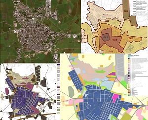
Case History: the SEA of the municipality of Apricena, Italy.
- Download the case history (PDF italian)
- Watch the Video and the PPT of the public workshop with the Municipality of Apricena (italian language)
Download an example of Preciso® land (PDF multi-layer)
It is possible to customize the view by selecting the layers
- Preciso® land - land use map of Apricena
CUS2010_apricena_WV2 (zip 23Mb) - Preciso® land - land use map Veneto Region
Preciso_Land_Veneto_MultiLayer (zip 50Mb)