

Satellite orthoimages for the timely monitoring of changes on the territory.
Nowadays, territorial transformation is increasing due to anthropic and natural impacts. The availability of cognitive and objective bases, which are easily interpreted and of limited cost, allows periodic monitoring of the territory.
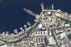
Preciso® Italia is a geo-informative product based on satellite ortho images, designed for applications requiring speed, frequent updates and high-level standardization.
It is the ideal reference for monitoring territorial transformation in quick time as a support for planning and management
Preciso® italia is available in two version to satisfy different application needs:
- Preciso® italia RGB is suitable for GIS/CAD applications.
- Preciso® italia MULTI is a perfect solution for the automatic elaboration of image processing.
Applications
Territorial monitoring; EIA; SEA; Illegal construction and environmental crime; Cartographic update; Risk forecast and assessment (fires and floods); Study of the water resources, marine and coastal; Wastes monitoring; Agricultural and forestry monitoring; Building and infrastructure monitoring.
Target
- Public administration
- Emergency services
- University and research bodies
- Engineering and planning companies
- Infrastructures, transport networks and energy resources
Benefits
- Timely updating on territorial conditions
- Objective information
- Easy interpretation of territorial conditions
- Availability of historical archive
- Reutilization of informative layer for application in different fields
- Limited costs of monitoring programs
Download
- brochure with the case history of Passante di Mestre (Venice, Italy) (PDF italian)
Preciso Italia Flyer (eng) on Scribd
Technical characteristics
Preciso® italia is available in two version to satisfy different application needs:
- Preciso® italia RGB is suitable for GIS/CAD applications.
- Preciso® italia MULTI is a perfect solution for the automatic elaboration of image processing.
Main characteristics
- High frequency of revisation and fast supply of data
- High level of standardization guaranteeing comparisons in time and space
- National and international conformity (ISO and OGC)
- High geometric accuracy
- High spatial and radiometric resolution
- Ready to use format for optimum use in most widely used GIS/CAD applications
Informative content
Georeferenced informative levels, geometrically congruent.
- Satellite orthoimages in ECW format
- Single orthorectified images in GeoTIFF, JPEG2000 lossless, IMG formats
- Standard metadata
- GCP (Ground Control Point) for the orthorectification process