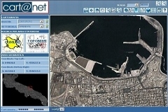
WebGIS solution for the management and consultation of large raster and vector datasets, ideal to distribute on-line catalogs of cartographic data.
A simple tool designed to create and manage geoportals in accordance to the INSPIRE directive.
Planetek has a long and extensive experience in the creation and customization of Geoportals, to help clients keep content up to date and to simplify the communication with users and stakeholders. Cart@net provides a powerful workflow to support the content management, and all contents can be geo-located. The layout is consistent with the Web portal that hosts the Geoportal: it ensures both the continuity in the aesthetic appearance and the full functionalities of the service offered.
Cart@net exposes the services foreseen by INSPIRE (Discovery, View, Download and Transformation Services). Users can easily access the Geoportal content and interact with an organization through the Forum, the News area, the multimedia Calendar and the integration with social networks like Facebook and Twitter. All spatial data are accompanied by their own license thanks to the content management interface of the Geoportal that helps, while publishing the data, to choose and easily produce the appropriate license to be associated with each dataset.
Download the Cart@net brochure (PDF)
Cart@net is a web application developed by Planetek Italia and is a registered brand at Ufficio Italiano Brevetti e Marchi di Roma (29/07/2002)
Brochure
Download the brochure with an overview on its versions, features and characteristics.
White Paper
The full technical document
View demonstration sites
Province of Vicenza, Italy
The geoportal of Vicenza Province, Italy
The Geographic Information System of Foggia Province on-line with the thematic maps of the "PTCP", Territorial Planning of Coordination for the Province
Contact our consultants
+39 0809644200
Technical support > Contacts >