
Decision Support for emergency management: the Civil Protection SDI of Regione Calabria
Natural phenomena with catastrophic developments is a topic dramatically arisen to the general attention in recent years. The level of risk in areas known to be dangerous also increased due to a careless use of land and resources.
One of the major challenges for the civil protection operators is to be prepared to handle the “uncertainty” which, from time to time, characterizes the calamitous event, making each of them somewhat “unique”.
The better answer to this challenge is the immediate availability of the most up-to-date and accurate information about the situation and the available resources. New innovative technologies in these scenarios should allow a more rational use of resources and a safer use of the land through sustainable planning models.

A geoportal for the Civil Protection
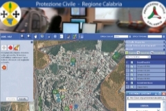
The Civil Protection of the Calabria region uses since several years an integrated tool for planning and emergency management, organized in a geoportal specially designed by Planetek Italia.
The geoportal is the front-end part of a bigger project aiming to the engineering, development and implementation of a GIS (Geographic Information System) as part of the Decision Support System (DSS) of the Civil Protection in Calabria. The solution implemented allows to support the prevention and emergency planning, including all methodologies and specifications (the organizational model required by the Italian Augustus method) adopted by the local government offices, responsible for managing and design of Civil Protection plans.
 Based on Cart@net, the tool developed by Planetek Italia for the geoportals creation, the Civil Protection GIS is implemented with advanced tools that provide a highly advanced state-of-the-art platform. The Geoportal represents the unique access point for both the regional Administration and all users and stakeholders. As an essential management tool, the geoportal is a secure reference point for all the activities related to the regional Civil Protection at any level and competence: territorial, functional and operational.
The Decision Support System
The system fulfills many functions of considerable help for the forecast and prevention activities, as well as for the emergency and post-emergency management:
- query , view, analyze, store and share geographical (and not only) information among all the civil protection operators;
- access and cross the information stored into an extensive database , constantly updated, about natural hazards and their implications on the area;
- anticipate and simulate scenarios and events;
- access the information even in adverse environmental situations (eg . through satellite connections);
- access the information even in emergency situations where there’s no internet connection available.
Especially in risk situations, the use of the Geographic Information System improves the efficiency and timeliness of the decisions, optimizing economies and priorities of actions. The Civil Protection GIS is therefore a perfect tool for the monitoring of policies and strategies, to deal with all environmental and urban emergencies.