
Automatic cloud-based geoinformation service for subsidence, landislides and groud displacement monitoring and analysis over time
Automatic cloud-based geoinformation service for ground displacement, landslides, subsidence monitoring affecting infrastructures, buildings and roads.
Monitoring is essential to assessing and predicting landslides or ground structural weaknesses, which could affect buildings or infrastructures.
To get accurate information over areas subject to subsidence or slow moving landslides, in order to anticipate potential risks, is fundamental for organizations and professionals working in civil protection, master plan management and insurance.
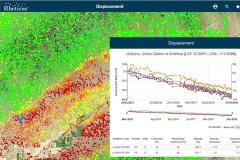
 Rheticus® Displacement is an automatic cloud-based geoinformation service designed to deliver periodically fresh and accurate satellite-based data and information to help Authorities and professionals monitoring ground surface movements.
The service provides continuous monitoring of areas subject to:
- landslides,
- natural- and/or human-induced subsidence in urban and suburban areas,
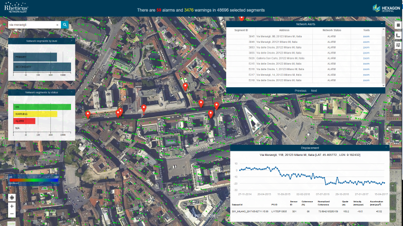
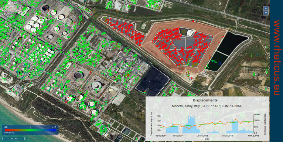
- stability of infrastructures (e.g. dams, bridges, buildings, road and railway networks, pipelines, electric towers, solar and wind farms, and so forth).
Using European Copernicus Sentinel-1 open data or COSMO-SkyMed data images and persistent scatterers techniques, the service is complementary to traditional survey methods, providing a long-term solution to ground instability monitoring.
Rheticus® Displacement provides detailed information on:
- Check of slope stability due to slow landslides movements;
- Analysis of the presence of phenomena of instability in the preliminary and the final phase of the planning of works and infrastructures;
- Monitoring the impact of the works and infrastructures construction on the slope stability;
- Check of the results of the interventions of slope stabilization.
Visit www.rheticus.eu and ask for a LIVE DEMO.
 Who is it for?
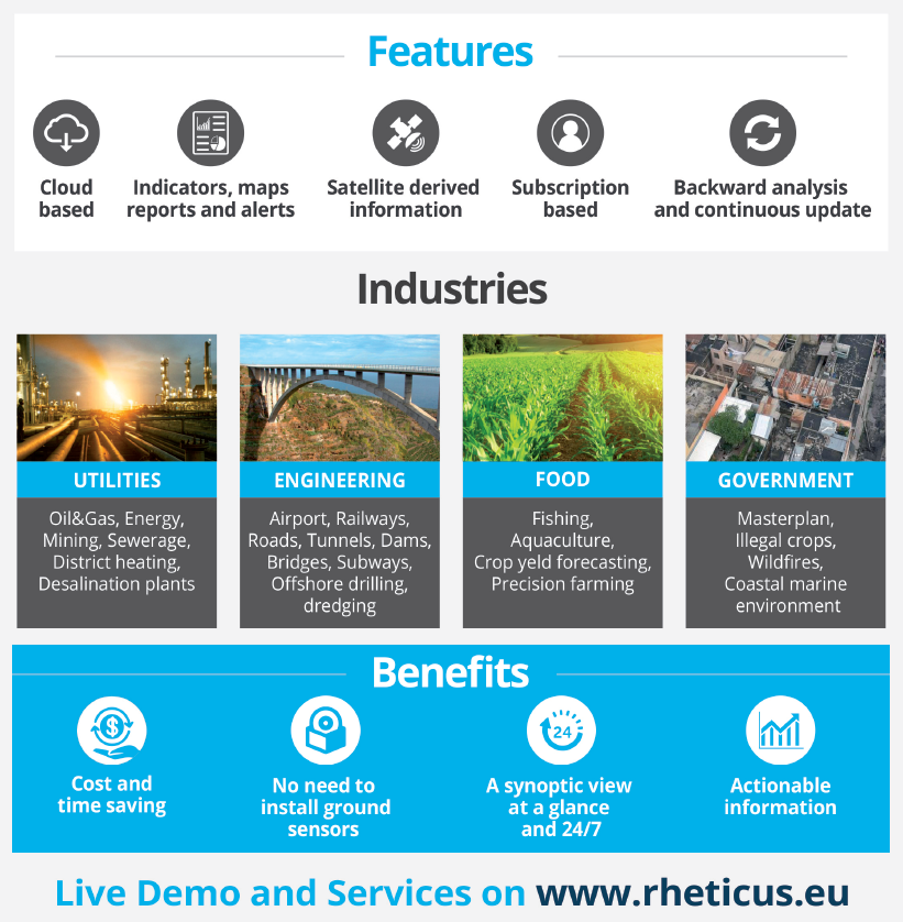
- Governmental Institutions in charge of urban planning and land monitoring, infrastructure monitoring, civil protection in case of landslides and/or subsidence phenomena, and so forth;
- Stakeholders within Engineering and Management Companies of Utilities networks, Oil&Gas, Electric Power, Renewable Energy, Mining, and Construction Industries as well as within Insurance, Business-to-Customer, Real Estate, Stock Exchange sectors;
- Scientific Communities and NGOs.
Applications
Timely identification of critical subsidence phenomena and landslides, optimization of on site monitoring activities, planning of emergency maintenance interventions.
Key Benefits
- Timely information is provided automatically at affordable prices
- Maps, reports and indices are actionable and available 24/7 from different platforms and devices
- Saves time and resources normally dedicated to data search and processing and information production
- Data and results are standardized and comparable over time
What's New
Rheticus awarded with Hera Group use case at Smart City Awards.
A new reward for Rheticus®, the satellite based monitoring service developed by Planetek. The use case was awarded the "Urban Environment Award". Read more
Featured Story
More Info
- Rheticus Displacement Brochure (PDF ENG)
- Rheticus Services description page
- Read and download all Rheticus brochures on Scribd (mobile friendly)
- Article "Satellite information-as-a-service"
- Article "Rheticus: low-cost satellite monitoring services on the cloud"
- Article "MM SpA uses Rheticus to monitor ground surface movements over Milan's sewerage network"
- Article "Building a simple answer to a complicated subsidence problem"
- Article "Cloud based geoinformation services for coastal water quality and marine resources"
Awards
- World Smart City Award 2019
- "Wichmann Innovations Award 2018" - INTERGEO 2018
- Marketing and Promotion Award - HxGN Live 2017
- “European EO product of the Year" - finalist
- Best Practices for Innovation 2016 Award
- "Application of the Year 2016” - OpenGeoData Italia
Rheticus® is an automatic cloud-based geo-information service platform, designed to deliver fresh and accurate data and information on our changing world.
It perfectly fits your monitoring needs
Rheticus® provides timely information that fits the needs of a growing number of business (applications). The information is provided as a service and includes maps, reports and geospatial indexes, designed to monitoring several phenomena.
Applications and services available
Territorial changes, urban dynamics and land use changes, ground displacements, landslides and infrastructures stability, new infrastructure and construction areas, wildfire burned areas or coastal sea waters quality.
Fresh worldwide information
Accessing directly to open data images (i.e. Copernicus Sentinel, Landsat 8 satellites), cartographic data and environmental information, Rheticus® provides timely information over the chosen area. Depending on the application, the service is provided on a monthly up to a daily base.
Accessible 24h multi-platform service
Subscribed users can access the information from multiple devices, such as personal computers, tablets & smartphones. Once logged in, users access to a personal area which consist of a dashboard designed to display summary information and user friendly analysis tools, which opens users to a complete set of information over the phenomena.
Accurate information at the lowest cost
Rheticus® guarantees always the best quality-price ratio available on the market, thanks to the use of open data, automatic processing procedures and its cloud based architecture.
The distribution of Rheticus® services is global. Thanks to our valued Authorized Distributors, you'll be able to ask information and receive assistance anywhere near your region.
Rheticus® services are standardized and ready to assist you in solving problems anywhere in our world. We know, anyway, that there is always a question to answer and a specific need to be satisfied. This is why, Planetek Italia is building a group of expert Authorized Distributors, which operates close to your geographic area.
Here is the list of Rheticus® Authorized Distributors https://www.rheticus.eu/authorized-distributors/
Do you want to join us as Authorized Distributor in your geographic area?
Contact us at info @ rheticus.eu
Vedi anche:
Awards