
Automatic cloud-based geoinformation service platform for territorial monitoring
Rheticus® is an automatic cloud-based geoinformation service platform, designed to provide fresh and accurate data and information on our changing world
Automatic cloud-based geoinformation service platform for land and infrastructure monitoring.
Geospatial information is today essential for organizations and professionals working in several industries. More and more, huge information is collected from multiple data sources and is also free available to anyone as open data.
Rheticus® is an automatic cloud-based geo-information service platform, designed to provide fresh and accurate data and information on our changing world.
Visit www.rheticus.eu to learn more and ask a LIVE DEMO.
Features and Benefits
It perfectly fits your monitoring needs
Rheticus® provides timely information that fits the needs of a growing number of business (applications). The information is provided as a service and includes maps, reports and geospatial indexes, designed to monitoring several phenomena.
Applications and services available
Territorial changes, urban dynamics and land use changes, ground displacements (landslide and subsidence), infrastructure stability, new infrastructure and construction areas, wildfire burned areas or coastal sea waters quality, aquaculture.
Fresh worldwide information
Accessing directly to open data images (i.e. Copernicus Sentinel, Landsat 8 satellites), cartographic data and environmental information, Rheticus® provides timely information over the chosen area. Depending on the application, the service is provided on a monthly up to a daily base.
Accessible 24h multi-platform service
Subscribed users can access the information from multiple devices, such as personal computers, tablets & smartphones. Once logged in, users access to a personal area which consist of a dashboard designed to display summary information and user friendly analysis tools, which opens users to a complete set of information over the phenomena.
Accurate information at the lowest cost
 Rheticus® guarantees always the best quality-price ratio available on the market, thanks to the use of open data, automatic processing procedures and its cloud based architecture.
What's new?
Rheticus awarded at World Smart City Awards with Hera Group use case.
An important reward for Rheticus®, the satellite-based monitoring service developed by Planetek, who received the "Urban Environment Award". Read more
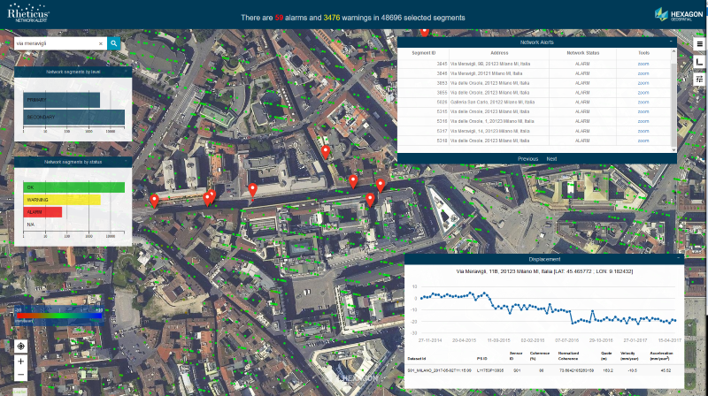
Rheticus® Network Alert: a dynamic geo-analytics tool to monitor pipeline fracture risks in integrated water and wastewater networks.
During the HxGN Live 2017 Conference Planetek Italia has launched Rheticus Network Alert, a dynamic geo-analytics service tool for ground instability and displacement monitoring in water and wastewater pipeline networks. The tool today is already used by several Integrated Water and WasteWater Companies to support maintenance activities with predictive satellite-based analytics.
MAIN RHETICUS CUSTOMERS
Among our clients some leading Italian and international companies, such as: ACEA, Acquedotto Pugliese, Aeroporti di Roma, Aguas Andinas (Chile), ANAS, Baton Rouge Water Company (LA, USA), ENEA, Eni SpA, Geal, Hera, IREN, MM SpA, SAIPEM, Terna, United Utilities (United Kingdom), Veolia (France), Viva Servizi, and local public administrations like Regione Autonoma del Friuli Venezia Giulia, Municipality of Niscemi, and the Decentralized Administration of Epirus and Western Macedonia (Greece). Rheticus is also providing data, maps and geoanalytics to EO4SD after earthquake reconstruction in Indonesia a programme of ESA and Asian Bank (ADB).
Visit www.rheticus.eu to learn more or write use at info @ rheticus.eu to ask a LIVE DEMO.
More Info
- Rheticus Brochure (PDF)
- Read and download all Rheticus brochures on Scribd (mobile friendly)
- Read the article "Satellite information-as-a-service" on GeoConnexion
- Read the article "Rheticus: low-cost satellite monitoring services on the cloud"
- MM SpA uses Rheticus to monitor ground surface movements over Milan's sewerage network
- Read the paper "Building a simple answer to a complicated subsidence problem" on Hexagon Geospatial
- Read the article "Rheticus: Satellite-based Information Services for Utilities" (Geomedia n.3/2018)
Awards
- World Smart City Award 2019
- Winner of the "Wichmann Innovations Award 2018" at INTERGEO 2018
- Finalist of the “European EO product of the Year” of EARSC Association
- Best Practices for Innovation 2016 awarded to Rheticus® Displacement
- "Application of the Year 2016” of OpenGeoData Italia
VIDEO
The distribution of Rheticus® services is global. Thanks to our valued Authorized Distributors, you'll be able to ask information and receive assistance anywhere near your region.
Rheticus® services are standardized and ready to assist you in solving problems anywhere in our world. We know, anyway, that there is always a question to answer and a specific need to be satisfied. This is why, Planetek Italia is building a group of expert Authorized Distributors, which operates close to your geographic area.
Here is the list of Rheticus® Authorized Distributors https://www.rheticus.eu/authorized-distributors/
Do you want to join us as Authorized Distributor in your geographic area?
Contact us at info @ rheticus.eu
Vedi anche:
Awards
- Winner of the "Wichmann Innovations Award 2018" at INTERGEO 2018
- Finalist of the “European EO product of the Year” of EARSC Association
- Best Practices for Innovation 2016 awarded to Rheticus® Displacement
- "Application of the Year 2016” of OpenGeoData Italia