
Cognitive Framework of marine and coastal areas and public defense works.
Urban expansion creates increasing pressure on coastal areas, along with land use change, growing tourism and construction of large infrastructures.
To control this phenomenon it is absolutely imperative to characterize and monitor the physical situation of the coastal system, from the prospective of sustainable growth at regional, provincial and local level.
Preciso® coast offers an update cognitive framework on the state of the coast and public defence works.
It is designed to support Urnban Planning in coastal areas, planning and management of natural areas and parks, monitoring of Posidonia and management of state maritime property.
Applications
- Coastal defence
- Territorial Planning
- SEA (Strategic Environmental Assesment)
- Tourism management
- Monitoring of Posidonia
- Quality of water
Target
- Public administration (State Maritime Property Office, Coastal Departments, Territorial Planning);
- Planners and Professionals
Benefits
- Support tools for terriotrial planning
- Clarity in criteria for the management of coastal tourism
- Easy and careful analysis of coastal changes
- Immediate identification of anthropic and natural changes
Tecnical characteristic
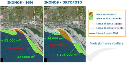
Preciso® coast permits the classification of every length of coast regarding its morphology and other variations (expansion, retraction or stability).
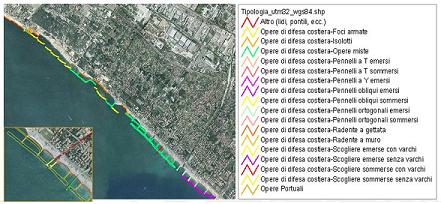
Works on ports are identified and classified according to type and use (industrial/commercial port, quay, dock, military port, etc.), while public defence works are surveyed and categorized by type (submerged and raised rocks, armoured delta, etc.)
Informative content
Preciso® coast is made up of geometrically congruent georeferenced layers*:
- Coastline
- Beach limit
- Raised beaches
- Port works
- Defence works
- Statistical indicators
- Preciso® Italia orthoimages
It is also possible to add DTM, where available, which permits the 3D visualization of data.
(*) Where there are historical data, informative levels can be supplied for each era, giving the dynamic trend of the coast.
Download