


Manhuma is designed to meet the needs of customers with obligations to conserve natural wetland habitats in Europe.
The interest towards humid areas is shown in other projects as for example Natura 2000, an European project to safeguard natural habitats, and the Ramsar convention of 1971. The focus on wetlands is driven by the recognition that these are among the most productive sources of ecological support on Earth, acting as habitats for many species, as flood control regions and sources of drinking water supplies.
Management of these areas is becoming an unavoidable element in policy decision making at all levels, local through to international.
The potential for Earth observation (EO) to plug the information gap for management planning of wetland areas, for implementing and monitoring conservation measures and then evaluating the effectiveness (impact) of these measures has attracted two strategic government customers from Germany and Italy and one NGO from France as partners in the MANHUMA project.
 To assist these potential customers in specifying and evaluating how EO-derived information can support wetland conservation and management, a team of three research and development partners (2 university departments, 1 SME), an EO data and service provider and a potential delivery service provider has been formed.
This group will work interactively with the customer partners to understand and service their information needs.
The Manhuma project founded under VI EC Programme "Environment and Climate" and support to CEO objectives.
Objectives
Based on extensive discussion with the customer partners and an initial analysis of their requirements, it is proposed that a portfolio of three geo-information products, based on EO data, should be developed to a prototype stage in MANHUMA.
These will be evaluated as to their effectiveness in three quite specific steps of the customers` decision making process:
- Step 1: The management planning process.
- Management planning involves three basic actions: delineation of wetland area, formulating conservation objectives and defining necessary action. It is in the definition of wetland boundaries and establishing the principal physical hydrologic, ecological and land use characteristics that EO has an important role to play.
- Step 2: Monitoring and control. In order to ensure that prohibited activities are not taking place and establish enforcement measures (or penalties). EO offers an ability to repeat measurement in a consistent way and to quantify change in the wetland area. Some of the main environmental threats occur outside the wetland areas themselves and so the wider coverage provided by EO could allow for a more comprehensive approach to monitoring than field investigation currently offers.
- Step 3: Evaluating effectiveness of conservation measures against the management objectives defined. EO provides both a visual and quantitative means to provide this evidence in a more convincing way than at present.
GEO-Information products R&D
Three geo-information products have been developed for each objective.
Geo-information product 1: Information for management planning
This product consists in the inventory and mapping of wetland areas, and involves three main axis of development :
- Identification of both continental and coastal wetlands, using a land cover segmentation and characterisation of humidity indexes from SPOT (including SPOT4 MIR data) and ERS SAR images. This identification will provide information on both vegetation cover and general soil units (specific to hydromorphic parameters and humidity states).
- Detailed characterisation and classification of specific continental and coastal wetlands by computer-assisted classification of airborne multispectral data to simulate future civilian VHR spaceborne systems.
- Detection of changes in landscape units due to agriculture practices and other human activities, using computer assisted photo-interpretation of historical satellite imagery.
Geo-information product 2: Monitoring and control
The research and development for this product is oriented mainly towards change detection in wetlands. In this first analysis has been observed the evolution of the vegetation cover and soil moisture within protected areas, with quantification of bio-physical changes using SPOT multispectral data. This analysis has been conducted on both continental and coastal wetland test sites, with data acquired at specific times of the year to coincide with specific agricultural activities and seasonal changes.
Geo-information product 3: Evaluation of the impacts of conservation measures and incentive.
This product has been developed applying an evaluation model of the landscape (based on the West midlands method).
At the end of MANHUMA project a CD-ROM concerning the activities of the project has been producted.
A wide section is dedicated to case studies to contribute substantially to providing the up to date information on European wetlands. This is required to avoid such loss and damage through both accidental and deliberate actions, and will enable Europe organisations to fulfil their commitments under international, European, national environmental and agro-environmental policies.
Benefits
The customer and service supplier benefits of Manhuma project are listed below.
1. Customer benefits
Environmental
- The project will provide a capability to use EO data to produce quantitative information on biotope composition and wetland taxonomy.
- This information can be assembled over a number of seasons and over several years so that it will be possible to monitor both spatial and seasonal changes in European wetlands.
- Identification of the wetlands which are on the verge of catastrophic change such as peat erosion, eutrophication or concentration of other water-borne pollutants.
- Contribute to other scientific research projects funded by the European Commission.
Management
- The very high resolution data such as (derived for the purposes of this project from airborne data) will provide maps at scales as large as 1:5,000.
- Development of new technologies to spread EO data with faster multi-media which will help increasing products and data sales.
- Policy
- The project will provide information to meet the needs of t policies such as the European Commission`s Directive on the Conservation of Natural Habitats, Ramsar convention of 1971and Dobris Assesment(EEA 1995).
- The role of EO data to police compliance with the policies will be an important element of future wetland management and conservation.
2. Service supplier benefits
Development of EO science and technology
- This project will therefore be able to assess the confidence with which optical and SAR data of wetland areas can be analysed using the classification and segmentation methodologies.
- Future SAR systems may well have improved interferometric performances which could be exploited in wetland monitoring.
- Development of commercial services
- Development of products and procedures will be valuable for future operational systems which use EO data for wetland analysis and monitoring.
- Evaluation of economics advantages provided by EO data use.
European competitiveness
- The methodologies developed during the project will place European organisations in a strong position to exploit the technology in other European wetlands and in wetlands outside Europe, such as those of the United States and Australia.
Innovation
The first innovative aspect of MANHUMA lies in the fact that it seeks to develop a common, global methodology for information extraction that can be applied specifically to wetland habitats on a European-wide basis, using existing means and techniques of Earth observation.
From a technical point of view, the work to be performed in MANHUMA also involves three innovative techniques of information extraction :
- The use of high resolution MIR data from the future SPOT4 satellite. This added spectral information reinforces SPOT`s ability to map and monitor land use, and increases its capability of detecting soil moisture variations.
- The use of SAR to improve humid areas identification.
- The use of multispectral airborne data to simulate VHR satellite data from future civilian systems.
The aim is to try and integrate VHR data with existing sources of satellite EO data such as SPOT and ERS SAR, in order to check the operational and technical feasibility and to prepare for future satellite VHR data.
From a thematic point of view, the use of VHR data will enable to monitor changes on a much finer scale than with the use of existing EO data, thus enabling to cover customer requirements even in areas with small cadastral cells.
The monitoring of the state and the transformation dynamics of different typologies assumes a central importance. EO sensors have been used for monitoring these sensitive wetland areas in order to manage and control both natural and anthropic changes, as well as for creating a workable GIS database for the region that has a great importance to the regional authorities for management and monitoring purposes.
Innovative aspects of the project:
- It enables the project to explore a better representative set of customer requirements as conservationists will be facing different management objectives, different environmental issues and pressures from other "end-users" of wetland habitats;
- It enables the project to tackle a wider range of technical issues. This will challenge the different methods and data sources we plan to research;
- It provides a broader basis for assessing exploitation potential - enabling the team to better understand whether this is a market which has to be developed by local (or regional) partnerships using specific methods and approaches, or whether there might be a set of more common products which could be developed in the long term, subject to local adjustment and refinement.
The humid areas are subdivided into continental and costal.
- The continental areas are: Upper Rhine Bassin,Alsace (F) and Baden-Württemberg (D)
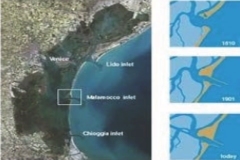
- The costal areas are: Po river delta, Venice Lagoon.
The Partnership
The project is characterised by the interaction and co-operation between the three following groups of partners: business development partners, research partners and end users and customers. This group works interactively with the customer partners to understand and service their information needs.
Partners are government and non government customers from Italy, Germany, France and United Kingdom.
The project co-ordinator is Spot Image (FR), and the working group was formed also by ESYS Ltd (UK), SERTIT (Service Régional de Traitement d`Image et Télédétection), IPF (Institut für Photogrammetrie und Fernerkundung), and Planetek Italia (Providers of EO-derived value-added products wchich worked on the main geographic information database used in the project). The role of this group was to produce and supply the high-level EO products according to the specific needs of the end-users and customers involved in the project.
Planetek Italia, has worked on product specification working closely with the partners involved in customer requirement analysis and has contributed to the development of a web site and to the Intranet for project information and data management. In cooperation with IUAV (Istituto di Architettura dell`Università di Venezia - Diploma in Sit) has been responsible for coastal humid areas.
End users complete the consortium of Manhuma including local authorities as (LfU) and non-governmental organisations, or trusts CSA (Conservatorie des Sites Alsaciens). The task for final users, together with IUAV, has been to organise surveys in the test areas and to supply up-to-date data in each phase of the project, in order to help the classification process.