Design thinking

Design thinking


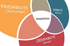
Identifying the best combination, over time, between the user requirements, the technological feasibility and the economic, social and environmental viability.


We adopt the principles of strategic design to create and develop solutions able to meet the requirements of our users, through the implementation of the best technologies available on the market, with full respect for economic, social and environmental sustainability.

The model we adopt in all our business activities is based on the principles of Strategic Design. The aim is to identify the best combination, over time, between the user requirements, the technological feasibility and the economic, social and environmental viability.

This model is based on the continuous development of prototypes and the progressive revision of the requirements, which lead us to develop solutions based on the real needs of our customers.

The customer is a "member" of the project team who actively participates in all project phases contributing at the implementation of solutions. This model leads to a true partnership with our users, based on a full and mutual trust, leading to informed decisions and the highest return in terms of satisfaction.

Among the main solutions underlying the projects and products we develop for our customers, our main services and products:

  • Rheticus® Automatic cloud-based platform providing vertical geoinformation services by subscription for territorial, infrastructure, and resource monitoring.
  • Preciso® Geo-information products, maps and indicators derived from satellite data, designed to provide cognitive frameworks for territorial monitoring.
  • Spacedge® Earth observation services infrastructure to make satellite instruments and assets accessible as-a-service.
  • EarthBIT Tool to process large SAR and hyperspectral images together with image streams (live video from e.g. drones) in real-time.
  • Cart@net® A versatile WebGIS application for publishing geospatial data catalogs on the Internet.
  • ImageryPack Annual subscription to obtain very high resolution satellite images anywhere in the world.
  • GetLOD & LOD4SDI Open and reusable solutions to publish geographic data on the Web in the form of Linked Open Data (RDF/XML).

Blog

Spotlight on

Today, I want to share an exciting story centered around my workplace, Planetek Italia, and its recent publication of the 2022 Impact Report. This document reflects our unwavering commitment to sustainability and the crucial role each of us can play in caring for our extraordinary planet. As a company involved in space, we understand...