hydrogeological and landslides risk monitoring through satellite interferometric techniques
The SLAM project was funded by the European Space Agency (ESA) within the framework of the DUP program (Data User Programme).
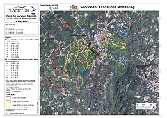
The SLAM service project was able to generate three products oriented to landslide monitoring and mapping. The products has been designed for the hydrogeological risk management.
The SLAM products has been derived from integration of data acquired by traditional methodologies and by Earth Observation into a GIS environment.
The user partnership in the project had a strong relevance, both for the production of a service useful to the organisations involved in landslide management and for the future dissemination of the proposed products and service.
The realization of SLAM project has been carried out by an international Consortium led by Planetek Italia (I) and by other five partners: Tele-Rilevamento Europa (I), Gamma Remote Sensing (CH), Spacebel (B), Geotest (CH) and the University of Florence (I).
Know more about:
- Executive Summary (1.5 MB) A brief description about the project and its activities
- Webstory on the Eurisy portal "Arno River Basin Authority: monitoring of hydro-geological phenomena using satellite imagery"
- Webstory on the ESA portal Description of the results obtained over the ARNO river basin with the comments of Prof. Casagli (GNDCI, Italian National Research Council Group for Hydro-geological Disaster prevention) and Dr. Sulli (ARNO Basin Authority).