
SAR data for GIS-oriented products

SAR data are not suitable for a direct use by GIS community.
Wide communities of users, ranging from urban planners to Earth resource managers or insurance brokers, have been managing territorial information in Geographical Information Systems.
They want to get relevant and updated information, ready to be inserted into their systems. In order to fulfil these requirements, the relevant information must be first extracted from the radiometric data gathered by the satellite sensors. Information must then be made available in a suitable format.
A study has been performed to address the aspect of the realisation of GIS products, generated by remotely sensed data, and designed to be closer to the final users needs.
In a study performed for the European Space Agency, Planetek investigated whether new, GIS-oriented products, derived from ERS-1 and ERS-2 Synthetic Aperture Radar (SAR) data, could be provided to these user communities.
The study has been focused on two key issues: the identification of the kind of product required by final users, and the specification of a suitable format for product distribution. In order to validate the concept proposed in this study, it has been decided to perform a detailed study of one product.
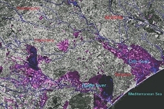
As a sample product we selected the flood map. The result is a vector map of the flooded zones, which is of immediate usage for final users.