
Catastrophic flood events

Sunday 10/09/2000 – After three days of heavy rain a torrent of floodwater struck a campsite between the towns of Soverato and Montepaone (province of
Catanzaro), in southern Italy`s Calabria region. The flooding river was located a longside the camp. After several days of heavy rain in the region the Beltrame
River broke its banks at dawn Sunday and brutally swept away everything in its path.
Overview
FEROX project is the response of Planetek Italia to ESA-ESRIN RFQ issue 1 revision 3 APP-AEP/JB/20000608a.
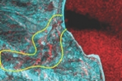
The analysis was conducted on the area related to the disaster caused by the Beltrame river on 10th September 2000 near Soverato, in south Italy.
The analysis has been based on three satellite scenes acquired by the Spot satellite and four scenes acquired by ERS-2 satellite.
As regards the SPOT satellite, one image was acquired before the event, on 27 August 2000, from the panchromatic sensor, the other two images were acquired after the event, on 17 September 2000, one from the panchromatic sensor, the other from the multispectral one.
Two of the processed SAR images where acquired before the event, in October and November 1999 while two data where acquired after the event on the 12 and 22 of September. The 1999 data can be considered a before disaster reference data and a good input to compare the river mouth and valley last year and this year after the disaster.

As ancillary data, to help the image interpretation, information derived from IGM maps has been used.
Maps have been used to derive a digital elevation model, used for automatic basin delineation. The river basin has then been calculated, delineating the
area to analyse to better understand the reasons of the striking event.
The most damaged area includes the basin of Beltrame where has been observed some landslide event in the mountain sector while the plane area has been
interested by flooding. As well known, a camp area has been destroyed by the flood.
The purpose of the presented results is to suggest possible points to analyse on ground, to better understand the event.