
The design and construction of roads and motorways are strongly affected by any movement taking place on the ground. Italy is particularly subject to unexpected ground movement including landslides, subsidence and earthquakes.
Avoiding or mitigating the consequences of such events poses significant challenges for planning, building and maintenance of road infrastructure.
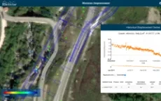
 Planetek Italia has developed a ground motion service called Rheticus that provides regularly updated nation-wide maps of ground movement based on data from the Copernicus Sentinel-1 mission. Sentinel-1's Synthetic Aperture Radar (SAR) instrument allows large-scale maps showing millimetric movements on the ground to be generated.
ANAS, The Italian Roads Authority, is now using Rheticus to assess risk and adapt road designs to reduce the danger for Italian motorways, tunnels and bridges.
The extremely accurate measurements of ground movement will allow road planners and builders to identify the risk of ground instability. As a result, the design of motorways can be made more resilient against future ground-movements.
Flavio Capozzucca (Anas), Geoff Sawyer (EARSC) and Giovanni Sylos Labini (Planetek) have been interviewed about the European Ground Motion Service (EGMS), part of the Copernicus Land Monitoring Service, and the use case of Abruzzo Region.
Read on the article on ESA website