
Wildfires represent a significant threat to environmental resources, with hundreds of thousands of hectares of burnt areas and invaluable loss of woods and biodiversity every year, in Italy and worldwide. Climate change increments the risk of wildfires, that raise the frequency, extent and severity of fires through increased temperatures and drought.
To correctly manage post-fire recovery activities, establishing a database of burn scars and keeping it up-to-date are crucial tasks.
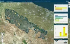
The Alta Murgia National Park in Southern Italy, one of Italy's 25 Parks, needed a solution that would continuously collect, visualise, and analyse burnt areas affecting its territory to oversee and report fire activities, support fire management and recovery planning.
In 2017, Planetek Italia was commissioned to assist the Alta Murgia National Park with monitoring and understanding areas affected by wildfires and developed Rheticus® Wildfires.
Rheticus® Wildfires is a high-performing and cloud-based geo-information service for post-fire monitoring. It provides end-users with essential information retrieved from Sentinel-2 satellites of the European Union's Copernicus Programme, together with other open data sources, through extensively tested models and algorithms.
The ESA Sentinel online website has published the full story.
Timeline
- 2025
- 2024
- 2023
- 2022
- 2021
- 2020
- 2019
- 2018
- 2017
- 2016
- 2015
- 2014
- 2013
- 2012
- 2011
- 2010