
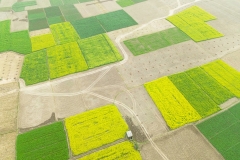
Digital Twin of the physical assets (land use, soil moisture, crops’ irrigation, etc.) for water management at basin level, aimed at supporting the water balance.
Optimum water resource management comes from a precise evaluation of water balance. There is the need for a tool which provides accurate and updated water balance.
Background & Objective
The Water Framework Directive (WFD; 2000/60EC) requires Member States to use their River Basin Management Plans and Programmes of Measures to protect and restore water bodies. At National level, the Ministry of Agricultural, Food and Forestry Policies established a database of water volumes used for irrigation. The Regions, on their end, must fulfil the (i) validation of such data, and (ii) the quantification and update of water volumes.
Water Digital Twin (WADIT) is an ongoing project started in 2023 coordinated by Apulian Aerospace Technology District (DTA) in partnership with Planetek Italia srl, Sitael SpA, the National Research Council (CNR), and the University of Bari Aldo Moro. Wadit project is co-funded by Minister of Enterprises and Made in Italy through the program "ACCORDI PER L’INNOVAZIONE".
The objective is to create a Digital Twin of the physical assets (land use, soil moisture, frequency and date of crops’ irrigation, irrigation techniques, etc.) for water management at basin level, aimed at supporting the water balance. WADIT focuses on analyzing water needs related to water use in agriculture to obtain a reliable estimate of actual water consumption in the cultivated fields.
The models to be studied, designed and implemented experimentally will allow Big Data (multi-platform remotely sensed data, data from agro-meteorological stations, core data from Copernicus services, commercial data, census data) to be processed using artificial intelligence techniques.
The system resulting from the engineering of the studied models, fine-tuned and integrated, will be able to provide, at district/basin level, the estimate of irrigation needs/consumption, periodically updated on the basis of the data acquired and processed in near real time on the area of interest.
WADIT provides:
- The production of dynamic land use maps;
- The identification of the location and extension of irrigated areas;
- The identification, through the use of artificial intelligence algorithms, of irrigated areas with a high probability of unauthorised water use;
- The production of KC crop coefficient libraries for different types of crops in different agro-ecological contexts;
- The use of weather and climate data, provided by the European Copernicus programme, to feed the models for calculating irrigation requirements;
- The creation of a digital infrastructure, the digital twin, to automate the process of processing, analysing and returning summary reports and analytical indicators.
Three study areas of 100 square km are planned in the Apulia region, Italy: Salento, northern Barese and Capitanata, in order to represent the different characteristics of the Apulian territory (crops, farm structure, availability of irrigation sources, services and quality of irrigation water). After setting up the models for the three test areas, the system will be applied to the entire regional territory. The digital twin will be able to create scenarios for short term estimation (12 months to take into account the variability of the herbaceous species) or for the simulation of land transformations that lead to radical changes in requirements in the long term (10/20 years as in the case of planting).
Users
- Public and private bodies responsible for water management, which must estimate and evaluate seasonal irrigation needs and consumption at basin/district/region level and, based on availability, plan use;
- Irrigation water service management bodies (public and private) as a tool for monitoring and controlling irrigation withdrawals at company level;
- Farmers and operators in the agricultural sector for planning investments in the cultivation of agricultural areas, both in the short term for annual crops and in the medium term for tree crops (times of 20/50 years).
Benefits
The main benefits for those responsible for managing water resources in using WADIT can be summarized in:
- Have updated and homogeneous data on the entire territory of interest for dynamic management of the water resource;
- Reduce the time for producing the reports required by legislation on the management of water resources;
- Carry out estimates and simulations by preparing different scenarios of use and availability of the water resource;
- Evaluate the territory's ability to support crop transformations based on the availability of irrigation resources to direct investments by private operators;
- Identify sites with a high probability of unauthorized use of water resources to implement water protection policies.
WADIT description on DTA website
VIDEO
WADIT presentation at "EO for Agriculture under Pressure" Workshop organized by ESA, WFP, FAO, GEOGLAM.
Project information
Client information:
ESA
Application fields: