
Providing Earth Observation and webGIS tools to locate and monitor underwater archaeological sites in coastal zone
The monitoring of the underwater cultural heritage is a priority of Public authorities (e.g. Ministry of Cultural Heritage, Institutions and local entities) that deal with conservation and restoration activities. These public bodies need cost effective, reliable and systematic survey techniques and means to accomplish their mission and everyday work.
The ITACA (Innovation Technologies and Applications for Coastal Archaeological sites) project aims to prove a management system for underwater archaeological sites in coastal regions. The discovering and monitoring service uses innovative satellite remote sensing techniques combined with image processing algorithms. The project develops a set of applications integrated in a system that pursue the following objectives:
- Search and location of ancient ship wrecks;
- Monitoring of ship wrecks, ruins and historical artefacts that are now submerged;
- Integration of resulting search and monitoring data with onsite data into a management tool for underwater sites;
- Demonstration of the system’s suitability for a service.
![]() The development of specific techniques, methods and tools based on the processing of Earth Observation satellite data makes possible the production of systematic survey of wide coastal areas, without any destructive impacts. In such way, ITACA is promoting a real integration between the use of compatible, non-invasive technologies, protection and conservation of resources and local cultural identities by providing high value tools in a cooperation framework.
The development of specific techniques, methods and tools based on the processing of Earth Observation satellite data makes possible the production of systematic survey of wide coastal areas, without any destructive impacts. In such way, ITACA is promoting a real integration between the use of compatible, non-invasive technologies, protection and conservation of resources and local cultural identities by providing high value tools in a cooperation framework.
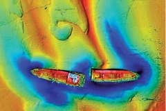
Analytically, high resolution synthetic aperture radar (TerraSAR-X, Cosmo-SkyMed) and multispectral satellite data (WorldView-2) will be combined to derive the relative bathymetry of the bottom of the sea up to the depth of 70 meters. The resulting data fusion will be processed using shape detection algorithms specific for archaeological items.
The new algorithms, the physical modelling and the computational capabilities will be integrated into a Web-GIS, together with data recorded from surface (2D and 3D modelling) and from underwater surveys Additional specific archaeological layers will be included into the WebGIS to facilitate the object identification through shape detection techniques and mapping.
The main specific objective of the ITACA project can be further defined as the assessment of the benefits of implementing a specific service for location and monitoring archaeological sites, coupled with technologies for underwater mapping using state-of-art data processing and fusion techniques and tools to manage underwater sites and guide excavations for the sake of:
- Improving the capabilities to locate and monitoring underwater archaeological sites in coastal zone towards the implementation and deployment of an innovative system integrating remote sensing and image processing techniques.
- Develop and deploy a management and operation tools for underwater archaeological sites. ITACA project includes the development of a WebGIS management and operation tool to integrate remote sensing data with a 3D representation of the underwater “reconstructed site” to provide guide the underwater operations ad complementing traditional mapping.
The system will be verified and validated through an extensive on-ground (sea) campaign carried out with both cutting edge technologies (side-scan sonar, multi beam echo sounder) and traditional means (submarine exploration with professional scuba divers) addressing a number of user test cases, such as:
- Search and location of ancient ship wrecks;
- Monitoring of ship wrecks, ruins and historical artefacts that are now submerged.
Verification of the developed methodologies will be provided using data sets from Greece (Metohi, Northern Greece), and Italy (Egadi Islands, Sicily)
The innovation character of ITACA addresses:
- remote sensing data processing methodologies which, at present, have not yet been analysed and exploited especially with the availability of new, high resolution active and passive sensors;
- enhancement of the image processing techniques already used in the frame of a project targeting archaeological items on land and development of fine tuning algorithms to consider the more complex underwater scenarios;
- web management and operation tools for archaeological coastal sites targeting the definition of risk maps and by integrating several information layers in a consistent tool;
- Analyses the impact of the new achievable observation products and tools on the marine market and related follow-up applications.
ITACA project is coordinated by Planetek Hellas E.P.E. (GR) and includes the following institutes and companies: Kell Srl (IT), NAIS Srl (IT), DHI GRAS (DK), I.EN.A.E (GR), FFCUL (PT), ANESTI Ltd (UK), Regione Sicilia (IT), ALMA sas (IT), CODEVINTEC Srl (IT), SME4SPACE (BE).
Download here the article on ITACA project from the GeoXperience Magazine
Test case Isole Egadi, Italy
[video:https://youtu.be/EQq0LR_4--o autoplay:0 width:560 height:315]
Field Campaign Metohi, Greece
[video:https://youtu.be/w_p2C_xJpJg autoplay:0 width:560 height:315]