
Forests from Space - feasibility study by Treedom and Planetek
The project Forests from Space is a feasibility study developed by Treedom and Planetek Italia under the umbrella of the European Space Agency (ESA) Business Applications / Space Solutions programme, and with the support of Fondazione E. Amaldi (FEA) as an Italian Ambassador.
Its aim is to bring Earth-observation satellite data into the realm of agroforestry and environmental impact monitoring — enabling a new, transparent and scalable model for forest planting, care and verification.
By combining multispectral data from satellites such as Sentinel-2 Copernicus) and hyperspectral data from, for example, the Italian satellite PRISMA (Italian Space Agency), together with very-high-resolution (VHR) commercial imagery (from missions such as PlanetScope, WorldView or SPOT), the project creates an advanced service.
This service allows agroforestry operators to visually verify the growth and health of planted forests over time.
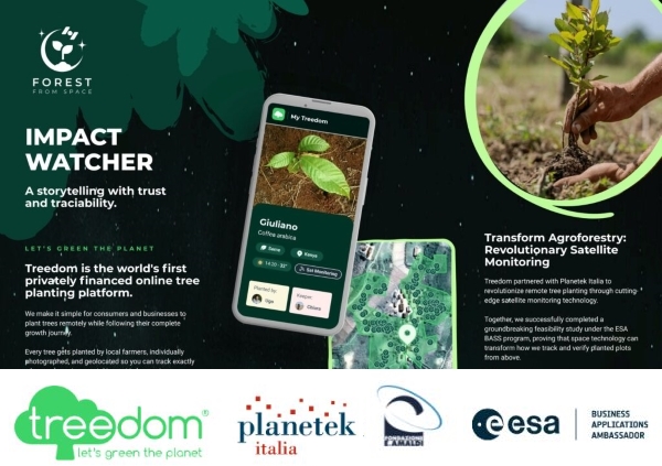
Forests from Space provides a unique service that allows monitoring forest health, land use, and the development of agroforestry projects, providing environmental indicators that can be viewed directly on the Treedom platform.
After the successful completion of the feasibility study, the next phases aim to extend the use of satellite data for predictive analysis and sustainable planning of future tree plantings, expanding the platform to new partners and institutions interested in measuring the impact of their environmental projects.
The benefits are manifold: customers receive tangible and verifiable proof of the environmental impact of their planting; farmers and forestry teams are supported in planning new agroforest areas; logistical errors are reduced; and overall operational efficiency is improved. What’s more, the project provides georeferenced data on land use and vegetation health — offering a new standard of transparency and accountability in reforestation efforts.
In summary, Forests from Space represents a concrete example of sustainable space economy — where orbital technology meets planetary regeneration.
The Role of Planetek Italia
Planetek Italia plays a fundamental role in making Forests from Space a reality. As a benefit-oriented company specialising in geomatics, space solutions and Earth sciences, Planetek brings to the table the technical expertise needed for integrating high-resolution Earth observation data into the workflows of agroforestry operators.
Specifically, Planetek has implemented the processes by which satellite and commercial VHR data are ingested, processed, analysed and transformed into actionable environmental indicators — such as land-use maps, vegetation health metrics, and more — that can be directly visualised through the platform operated by the tree-planting company (e.g. Treedom).
In this way, Planetek enables a fusion of traditional agroforestry practices with advanced space-based remote sensing: it ensures that each planted tree, each area of forest, is not only virtual hope, but documented impact — tracked over time, with precision and reliability.
Finally, thanks to this collaboration, Forests from Space shifts from a feasibility concept to a potentially scalable, operational solution — capable of being expanded to new regions, partners and institutions interested in monitoring the environmental footprint of their afforestation or reforestation projects.
Read more: