
The ESA Coastal TEP online service provides access to an extensive archive of coastal information, from over 20 yrs of Satellite & other data archives, for a wide range of uses: environmental monitoring, site assessment, maritime security & safety, coastal awareness, coastal planning & blue growth.
For more than 20 years, Earth Observation satellites have provided a wealth of data. In the coming years, the Sentinel missions, along with the Copernicus Contributing Missions as well as Earth Explorers and other, Third Party missions will provide routine monitoring of our environment at the global scale, thereby delivering an unprecedented amount of data. This expanding operational capability of global monitoring from space, combined with data from long-term EO archive, in-situ networks and models will provide users with unprecedented insight into how our oceans, atmosphere, land and ice operate and interact as part of an interconnected Earth System.
In this context, ESA's launched its latest initiative, the Thematic Exploitation Platforms (TEPs), to help society extract, and benefit from, the wealth of information held in archives, and data streams of Earth Observation Data.
 A TEP is essentially an online platform, a gateway, which allows researchers to rapidly process EO data and extract end-user information from them. Experts can develop, e.g., processing algorithms online, with all the processing done in the cloud. A TEP also hosts an online collaboration hub, where experts and users can exchange ideas, co-develop algorithms, and work together across the globe. The overall goal of TEPs is to work as enablers. Allowing better, more informed and relevant decisions (in C-TEPs case on our coastal environment and resources), and rapid expansion of knowledge of our coastal environments and how we use them.
The Coastal TEP (C-TEP) is focused on extracting coastal information from Satellite data archives and NRT data streams. Information extracted has a wide range of uses including environmental monitoring, site assessment, maritime security and safety, coastal awareness, coastal planning and blue growth. In particular information extracted using the TEP could be quickly put to work informing better decision making, and enable cutting edge applied coastal research.
The Coastal TEP is an online service which will provide access to an extensive archive of over 20 years of EO data, near-real-time (NRT) satellite data streams, in-situ measurements, and the tools necessary to process and extract information from said data.
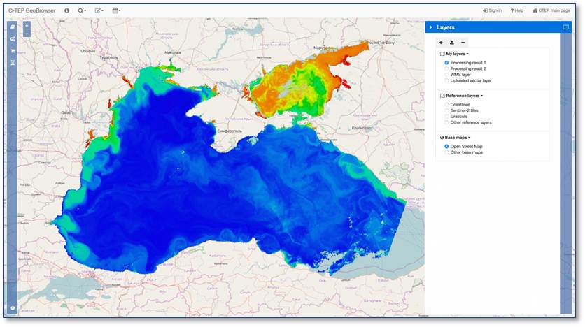
C-TEP will provide users the ability rapidly extract both temporal and spatial information, and conduct statistical analysis. In addition, C-TEP will provide a platform to share knowledge, applications and algorithms, fostering collaborative analysis of our coastal areas by the scientific community, government agencies and the general public.
C-TEP moves processing to the data, mitigating common problems such as data storage. It will enable rapid data access, rapid development and testing of algorithms. Currently, areas of particular interest to the C-TEP team include water quality, habitat classification, shallow water bathymetry, coastal altimetry and turbidity estimation.
The final objective of the C-TEP is to provide a virtual platform where EO data and in-situ coastal data may be accessed, processed, analyzed and shared for the enhancement of maritime management, research and R & D sectors. To do so C-TEP will provide access to:
- Over 20 years of archived and NRT satellite-derived EO data
- Virtual computing/processing tools and Big Data exploitation methods
- Support services and a community of practice
- Forums and professional networks focused on open community collaboration
C-TEP is being undertaken by a Consortium of ten partners based in six European countries. Led by ACRI-ST, the consortium consists of experts in the fields of Earth Observation and maritime management from a wide range of national and regional research centres and management agencies.
Prime Contractor: ACRI-ST. Other Consortium partners: Advanced Studies and Research Center (Romania); CATALYSTS (Austria); Centre National d’Etudes Spatiales (CNES) (France); Consiglio Nazionale delle Ricerche (CNR) (Italy); Deutschen Zentrums für Luft- und Raumfahrt (DLR) (Germany); Daithi O’Murchu Marine Research Station (Ireland); Planetek Italia (Italy); Thales Alenia Space (France); University College Cork (Ireland).
[Video] Presentation of the Coastal TEP at EO Open Science 2017 (from min. 1:45:00)