
Satellite data to support aquafarmers in molluscs harvesting on the Italian Adriatic Coast.
Aquaculture represents a source of sustainable and high-quality sea food products. As for the agriculture sector, aquafarming companies are looking for detailed and precise information to plan the optimal time to harvest and sell their products. Besides this, climate change effects are impacting the production and seasonal trends related to the harvesting of molluscs. Companies working in aquaculture are now searching for innovative solutions to collect information to monitor environmental parameters (water temperature, sea-level rise, water eutrophication, etc.), and associated risks, in order to optimise the management of the production sites.
Planetek Italia is supporting BIVI Srl in facing a series of challenges related to the frequent droughts that cause a depletion of nutrients and phytoplankton, with negative impacts on product quality (low meat products). The risk is a reduction of the production impacting the profit margins. In particular, the company needs to assess chlorophyll levels, which reflect phytoplankton density and composition, and compare them with those of the previous years.
How satellites can help aquafarming
 Satellite imagery is a useful tool to collect timely information on a specific maritime area and to develop cost-effective solutions for aquafarmers.
Back in 2019, BIVI Srl — as a member of the Italian Association of Mediterranean Aquafarmers (AMA) — participated in a project funded by the Italian Ministry of Agriculture, Food and Forestry Policies (MIPAAF), which aimed at fostering the adoption of new technologies in the aquaculture sector. Planetek Italia in collaboration with Blue Farm, a spin-off of the Ca’ Foscari University, developed a service platform for fish farmers called Rheticus Aquaculture, mainly oriented towards molluscs harvesting.
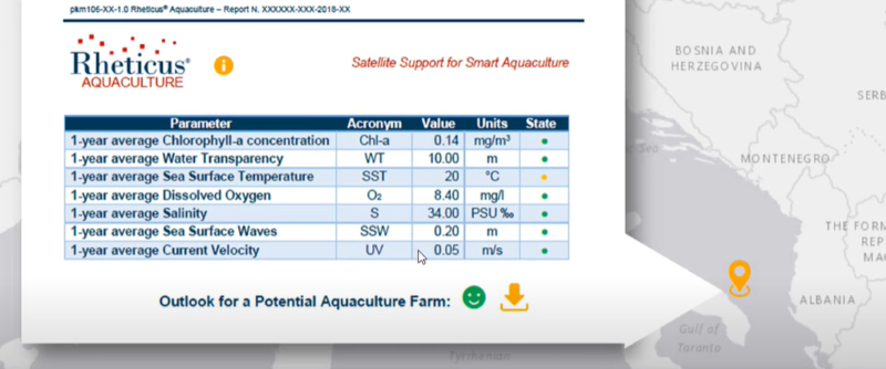
Rheticus Aquaculture is a subscription and cloud-based service that provides geospatial information data and forecasting models and statistics based on information derived from satellites and in situ observations.
The information included in the Rheticus service is a combination of satellite images, cartographic and environmental information available online as open data. Great support to the service comes from the software MITILAB, which provides in one single platform all the information on the work done and stocks on the harvesting area, such as maps and harvesting techniques.
The purpose of the system is to provide mussels farmers with data and forecasts that can be downloaded from the platform and easily understood even without a technical background.
The results
Rheticus Aquaculture was used by BIVI Srl and other aquafarms along the Adriatic coast between 2019 and 2020, only for mussels farming.
The solution provided the company with clear and periodical information on chlorophyll levels in the Adriatic Sea and a forecast of the expected growth of mussels.
The service helped BIVI Srl to optimise time and to better plan the harvesting season. In particular, BIVI relied on the information related to the weekly mussels’ growth, including seeding data, stocking dates, 7-day forecast of mussel growth, and the comparative analysis between the current growth rate and the previous growing season.
Moreover, BIVI Srl retrieved historical data on chlorophyll concentrations over the last 10 years, which were very useful to better understand the on-going climate change effects on the harvesting.