
By using high definition images of Cosmo-SkyMed satellite ENEA and Planetek Italia will detect landslides and any 'anomalies' on buildings, bridges and viaducts.
The hydrogeological instability is one of the greatest problem pervading the Italian territory. The use of satellite technologies is essential to support risk prevention activities over land, infrastructures and people, by monitoring and analyzing the movements of the earth's surface over time.
The use of high definition satellite images of the Cosmo-SkyMed satellite and the development of a system for analyzing landslides and any 'anomalies' on buildings, bridges and viaducts, is the object of the agreement signed by ENEA, Planetek Italia and the Municipality of Messina, Italy which will allow monitoring a critical area located in Altolìa district, Messina, Italy.
Using the most advanced satellite technologies, the research team will identify new landslides and monitor existing ones. In addition to the 'real time' satellite monitoring activity, the team will develop a historical study (for the period 2014-2018) and a forecast system by 2023 of the hydrogeological instability of the whole area of about 25 km2. In addition, a team of ENEA geologists will be involved in the field to verify natural phenomena, in order to compare the information processed from satellite images.
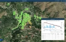
The research team will use data of the Italian "Cosmo-SkyMed" radar satellite constellation, a dual mission for civil and defense use. High definition images of the territory will be collected every 30 days, detecting millimetric ground surface movements.
Images will be then processed by Planetek Italia's geo-information service platform (Rheticus®), to calculate geoanalytics and speed maps able to reveal any 'anomalies' on buildings, bridges and viaducts.
"In this way we will be able to understand if something has changed in the time interval between the satellite acquisitions and to verify and measure the deformations of the soil caused by landslides, volcanic eruptions and earthquakes with extreme accuracy.
But not only. In fact, the use of satellite data will ensure the reduction of territorial control costs and a more effective monitoring of risk areas which will allow the municipal administration to implement preventative safeguard measures", explains Francesco Immordino, ENEA researcher of the laboratory of "Technologies for the dynamics of structures and the prevention of seismic and hydrogeological risk".
With satellite monitoring it is possible to cover a very large area in very short times: after Altolìa, the next step will be to extend the study to the whole Municipality of Messina and to that of Niscemi, in Sicily. "But this new type of investigation that combines satellite data with field surveys, aims to become a "model" for the continuous monitoring and forecasting of the hydrogeological instabilities applicable in any other part of Italy", says Immordino.
Read more on ENEA Website
Timeline
- 2025
- 2024
- 2023
- 2022
- 2021
- 2020
- 2019
- 2018
- 2017
- 2016
- 2015
- 2014
- 2013
- 2012
- 2011
- 2010