

Integration of satellite remote sensing observations with urban ground stations into urban meteorological and climate modelling to help decision and policy makers in better preventing the impact of Urban Heat Island (UHI) through appropriate alert systems and in reducing the risk, with dedicated urban land planning.
What is Urban Heat Island?
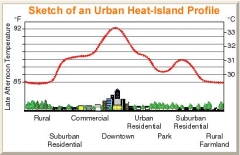
Urban Heat Island (UHI) effect is one of the most typical phenomena of urban climate, for which the temperature of the central urban locations are several degrees higher than those of nearby rural areas of similar elevation.
Surface and atmospheric modifications due to urbanization generally lead to a modified thermal climate that is warmer than the surrounding non-urbanized areas, particularly at night.
Natural vegetation removal and the usage of building materials (concrete, asphalt etc.) leads to enhancement in land surface temperature and air temperature, due to augmented sensible heat flux and diminished latent heat flux.
Peculiar structure of cities (high buildings, narrow streets etc.) also alters air circulation fluxes, eventually exacerbating the phenomenon intensity.
 Several negative effects are due to this increase in urban temperatures:
- enhanced energy demand
- air pollution increase (due to physical and chemical reactions not yet fully understood)
- water demand increase
- health problems
Project objective
The European Space Agency (ESA) funded in the programmatic framework of the Data User Element of its 3rd Earth Observation Envelope Programme (EOEP 2008-2012), the Urban Heat Island and Urban Thermography Project.
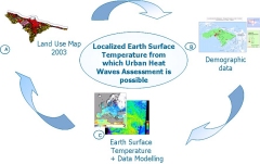 The aim of the project is the integration/assimilation of satellite remote sensing observations - mainly Thermal InfraRed (TIR) channels - with urban ground stations (temperature, relative humidity and wind speed) into urban meteorological and climate modelling to help decision and policy makers in better preventing the impact of Urban Heat Island (UHI) during heat waves, through appropriate alert systems and in reducing the risk, through dedicated urban land planning.
A second and important objective of the project is to study the mission requirements for a dedicated high resolution TIR satellite sensor that could serve at best the needs of all public administrations that request more adequate UHI observations in metropolitan areas.
Planetek Italia, as Prime of a Consortium of 6 organisations from 5 EU Countries (Planetek Italia, Italy; Edisoft, Portugal; Indra, Spain; NOA-ISAR, Greece; VITO, Belgium; Eurosense, Belgium), is working to provide to 10 European Cities (Bari, Athens, Thessaloniki, Lisbon, Brussels, Madrid, Seville, Paris, Budapest, London) different and ad hoc products and services to benefit users groups and ultimately the population most at risk.
 UHI products and relevant services are:
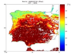
- LST products/services - Land surface temperature (LST) is a good indicator of the energy balance at the Earth's surface and the so-called greenhouse effect because it is one of the key parameters in the physics of land-surface processes on a regional as well as global scale.).
- Surface parameters- Surface albedo, surface emissivity and surface roughness length. These parameters play a key role in the estimation of the Energy Balance processes and so of the Energy Budget of that surface.
- Air Temperature climate modeling products/services - Modeling Air Temperature (AT) at different resolution are provided through the usage of several sensors: MSG Seviri for low resolution services (3-5 km), ATSR, AVHRR, MODIS etc. for low resolution (< 1KM), Aster and Landsat for high resolution (about 100m), and airborne sensor for very high spatial resolutions (5-30m).
- NRT and forecast products/services - A number of products / services are provided in NRT and 3 days forecasts to estimate Air Temperature at about 1 km spatial resolution, to obtain indexes useful for health management, to derive UHI maps for the identification of critical heat areas into urban agglomeration, to generate Hazard and Risk maps for emergency planning
- Thermographic products/services - It is the measurement of the earth surface through a thermographic camera/scanner on an airborne or space born platform. On a thermographic map, how warm or cold the surface was at the moment of acquisition can be seen.
- Energy balance study - The energy efficiency of cities can be studied through the thermographic mapping technology which provides information on amount of energy savings obtained by the installation of specific materials on roofs or pavements and planting vegetation, thermal efficiency of building and pavements for new development and building purposes.
In detail, 18 different products are implemented to contribute to monitor Urban Heat Island phenomena and to provide new tools for an effective management of such phenomena.