


Satellite, sighting towers and community collaboration. Inside the Alta Murgia National Park, the fight against fires is done with integrated actions and, from this year, with cutting-edge technological equipment, which allow the implementation of prevention activities, as a support for active struggle and post-event investigation.
It was presented on 10 November 2017, in Bari, Italy, the report on the burnt areas identified and monitored during the summer of this year in the area of Parco Nazionale dell’Alta Murgia.
The most critical season for wildfires and forest fires is now behind us. The first accurate information about the areas involved, derived from monitoring campaigns will be available in several months. This is not the case for the Alta Murgia National Park, which this year has adopted satellite technologies to carry out an analysis in a very short time. The information, in fact, was collected and made available after only two months, compared to the usual 12/18 months of waiting.
Wildfires facts
2017 will be remembered as a "hot" year globally, California and Portugal for weeks have been covered by fires that have burned thousands of hectares. Even Italy continues to burn and until October in Piedmont fires as well as burning hundreds of hectares of forest have lapped population centers and infrastructures. In order to counter this phenomenon, a series of initiatives are adopted that, on the whole, allow us to limit something which appears, for various reasons, inevitable.
Parks have the main function of defining the rules that regulate the activities in the park area and an appropriate monitoring activity, can significantly affect the success in the fight against fires, which involves several institutional entities. In Puglia region, in addition to the Park Authorities, the regional administration with the Civil Protection and its ARIF Agency, the Carabinieri, have inherited some of the functions that were carried out by the State Forestry Corps, the Fire Brigade, the Municipalities.
Alta Murgia National Park in this context has activated a series of initiatives to prevent the start of wildfires and, in case of start, to activate rapid intervention teams.
As a first activity, the Park has committed itself over time to creating a network of relationships with the subjects operating in the park to build awareness of the importance of protecting the territory in which they operate, which represents a source of income as well as the place in which they live. This awareness is an essential part for the success of any initiative including the fight against fires.
From the point of view of prevention, a series of rules have been activated, some of which are also accepted by the regional legislation, which regulate the activities in the park, also of an economic nature, in order to prevent activities that may provoke or induce the creation of fires. These include the ban on the collection of mushrooms and asparagus in the areas covered by the fire, the regulation of the burning of stubble, to mention those that probably have a greater potential impact.
For the early detection of outbreaks a network of observation points has been created that are widespread throughout the territory. These points are continuously monitored, throughout the fire season, by operators through the activation of agreements with voluntary associations, which are able to activate the alarm at the first signs of the fire. In some critical areas, video surveillance systems have been activated that bring together images acquired by cameras to an operations center that is able to interpret them and identify the outbreaks at birth.
Satellite monitoring
The Alta Murgia National Park this year has adopted, - the first example in Italy, followed by the Majella National Park - a satellite monitoring service with the aim of increasing investigation and monitoring capabilities of burned areas over time.
A continuous monitoring service was implemented using Rheticus® Wildfires developed by Planetek Italia, which is able to automatically process the images immediately after they have been collected by the European Sentinel-2 satellite constellation.
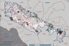
The activation of the service allowed the creation of a report on the areas covered by the fire in the Alta Murgia National Park area in the period July-September 2017. The processing of satellite data allowed on a weekly basis, the identification and contouring of burnt areas, the classification of events based on the degree of severity of the damages caused by the fires on the vegetation and theeir allocation by Municipality of reference.
All these are fundamental information, which allows a clear and detailed picture of the extent and size of the phenomenon, useful for planning and implementing actions to prevent and manage the areas covered by the fire, to make preliminary economic assessments of the interventions to be carried out.
Facts and figures of wildfires in summer 2017 in Alta Murgia National Park
In the period July 7th - October 5th, 2017, the areas covered by the fire amounted to 270 hectares.
There are 16 fires registered, 3 of which with an area of about 50 hectares. These large-scale fires occurred two in August and one in September. The municipality with the largest area covered by the fire is Andria with 70 hectares, followed by Corato and Minervino Murge.
The types of species most affected were the grazing areas and arable land for 132 and 44 hectares respectively. The wooded areas affected by fires were about 35 hectares and of these slightly less than one hectare presented a high degree of severity of damage to the vegetation.
Press releases (Italian):